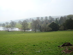
Up Cerne
| Up Cerne | |
| Dorset | |
|---|---|
 Up Cerne | |
| Location | |
| Grid reference: | ST657027 |
| Location: | 50°49’24"N, 2°29’14"W |
| Data | |
| Postcode: | DT2 |
| Local Government | |
| Council: | Dorset |
Up Cerne is a hamlet to the west of the River Cerne between Minterne Magna and Cerne Abbas in Dorset.
The hamlet is centred around the 17th Century Up Cerne Manor[1] but also includes a number of smaller thatched cottages.
Running through Up Cerne is the Wessex Ridgeway which also forms part of the local Cerne Valley Way.[2]
Outside links
| ("Wikimedia Commons" has material about Up Cerne) |
References
- ↑ National Heritage List 1118810: Up Cerne Manor House
- ↑ Rogers, Joseph (22 August 2017). "West Dorset - Walking the River Cerne". http://www.thetravelpocketguide.com/2017/08/places/west-dorset-walking-river-cerne/.
