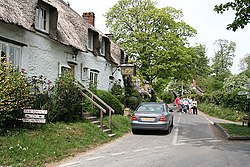
Plush, Dorset
| Plush | |
| Dorset | |
|---|---|
 The Brace Of Pheasants public house, Plush | |
| Location | |
| Grid reference: | ST715022 |
| Location: | 50°49’6"N, 2°24’24"W |
| Data | |
| Local Government | |
| Council: | Dorset |
Plush is a small village in Dorset, in the west of the county near Piddletrenthide, eight north of the county town, Dorchester. It sits in a small side-valley of the River Piddle at an altitude of 430 feet and is surrounded by chalk hills which rise to 823 feet at Ball Hill, half a mile to the north-east, and 856 feet at Lyscombe Hill, a mile and a half to the east.
Plush consists of a few thatched cottages, a public house, a Regency manor house and a small church dedicated to St John the Baptist; the church was designed in 1848 by Benjamin Ferrey, a Gothic Revival architect and close friend of Pugin.[1]
References
- ↑ Nikolaus Pevsner: The Buildings of England: Dorset, 1972 Penguin Books ISBN 978-0-300-09598-2page 317