Horton Heath, Hampshire
| Horton Heath | |
| Hampshire | |
|---|---|
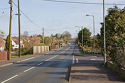
 The main road through Horton Heath | |
| Location | |
| Grid reference: | SU496172 |
| Location: | 50°57’10"N, 1°17’41"W |
| Data | |
| Postcode: | SO50 |
| Local Government | |
Horton Heath is a semi-rural village in the south of Hampshire, about three miles south-east of Eastleigh town centre. It adjoins Fair Oak.
The village greatly expanded during the late 1980s and 1990s with developments such as The Drove and Meadowsweet way. A new Village hall was also built at this time.
There are two pubs in the village: 'The Brigadier Gerard' and 'The Lapstone Inn'.
Pictures
| ("Wikimedia Commons" has material about Horton Heath, Hampshire) |
 |
 |
