Durlston
| Durlston | |
| Dorset | |
|---|---|
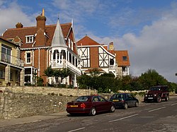
 Houses on Durlston Road | |
| Location | |
| Grid reference: | SZ030778 |
| Location: | 50°36’2"N, 1°57’29"W |
| Data | |
| Post town: | Swanage |
| Postcode: | BH19 |
| Dialling code: | 01929 |
| Local Government | |
| Council: | Dorset |
| Parliamentary constituency: |
South Dorset |
Durlston is an area of Swanage, in Dorset. The area was developed by George Burt as a residential suburb, and includes many large Victorian villas as well as modern developments.
Durlston Country Park
Durlston has a country park overlooking Durlston Bay, with a mock castle built in 1887. The castle (a restaurant when built, and still in use as a café) is surrounded by stone ornaments, including the Great Globe, three metres in diameter. The area is now owned and managed by the council. There is a modern visitors' centre on the hillside above the castle.
Outside links
| ("Wikimedia Commons" has material about Durlston) |
