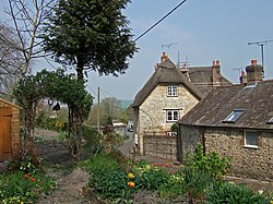
Bradford Peverell
| Bradford Peverell | |
| Dorset | |
|---|---|
 Bradford Peverell | |
| Location | |
| Grid reference: | SY658930 |
| Location: | 50°44’10"N, 2°29’6"W |
| Data | |
| Population: | 370 (2011) |
| Post town: | Dorchester |
| Postcode: | DT2 |
| Local Government | |
| Council: | Dorset |
| Parliamentary constituency: |
West Dorset |
Bradford Peverell is a village in Dorset, two miles north-west of the county town, Dorchester. It is sited by the south bank of the River Frome, among low chalk hills on the dip slope of the Dorset Downs.
The A37 road between Dorchester and Yeovil passes to the north of the village on the other side of the river's water meadows.
In the 2011 census the population of the parish (which includes the hamlet of Muckleford to the north-west) was 370.
History
In the 1st century a Roman aqueduct ran through where the village is now sited; it followed a line from Notton, a few miles upstream, to Dorchester,[1] which then was the Roman town of Durnovaria.
Bradford Peverell is the birthplace of the historian John Hutchins, who was born here in 1698.[1] His work on the history of the county, History and Antiquities of the County of Dorset, was published in 1774.
In 1850 the parish church was rebuilt in a 13th/14th-century style, though various fittings and monuments were retained from the earlier building. The new design was by Decimus Burton.[2]
Outside links
| ("Wikimedia Commons" has material about Bradford Peverell) |
References
- ↑ 1.0 1.1 Roland Gant (1980). Dorset Villages. Robert Hale Ltd. p. 142. ISBN 0 7091 8135 3.
- ↑ Bradford Peverell in 'An Inventory of the Historical Monuments in Dorset', Volume 1: West (1952), pp. 34-36
