Elmore
| Elmore | |
| Gloucestershire | |
|---|---|
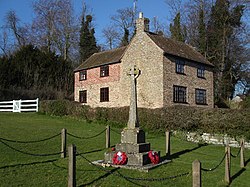
 War Memorial | |
| Location | |
| Grid reference: | SO787151 |
| Location: | 51°50’5"N, 2°18’35"W |
| Data | |
| Population: | 219 (2011) |
| Post town: | Gloucester |
| Postcode: | GL2 |
| Dialling code: | 01452 |
| Local Government | |
| Council: | Stroud |
| Parliamentary constituency: |
Stroud |
Elmore is a village on the south bank of the River Severn in Gloucestershire, to the east of the county town, Gloucester. Elmore is in a broad loop of the tidal river downstream of the city, and just outside the grasp of its urban spread; to the west of the southernmost suburb, Quedgeley.
The parish had a population of 219 at the 2011 census.
The village is the location of Elmore Court, a Grade II listed mansion, which has been the family seat of the Guise Baronets for nearly 800 years.

Parish church
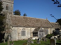
The parish church is St John the Baptist, and stands outside the village, about a mile and a half to the west. The church seen today was built in the 13th century: the north aisle, which was the original chancel, is from this time, as is the lower of the three sections of the tower. The Church was restored in 1879-80 by F S Waller.
The church has a remarkable array of tabletop tombs dating from the 15th century onwards. One tomb chest dates to 1472 having an incised line portrait of a knight in armour and inscriptions commemorating "Johannes Gyse and Alicia his wife". Another bears two weeping figures. The ruined Guise family mausoleum is to the west of the church.
Outside links
| ("Wikimedia Commons" has material about Elmore) |
- Elmore Parish Council
- History of St John The Baptist Church, Elmore: Hardwick Benefice
