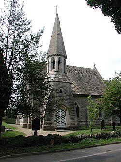
Edge, Gloucestershire
| Edge | |
| Gloucestershire | |
|---|---|
 Church of St John the Baptist | |
| Location | |
| Grid reference: | SO848098 |
| Location: | 51°47’13"N, 2°13’16"W |
| Data | |
| Post town: | Stroud |
| Postcode: | GL6 |
| Dialling code: | 01452 |
| Local Government | |
| Council: | Stroud |
| Parliamentary constituency: |
Stroud |
Edge is a village in Gloucestershire, amongst the Cotswolds. It stands a little to the west of Painswick (to whose civil parish it has been allocated), on a hill-edge marking the western extent of the Cotswolds, before the land drops down to the Vale of Gloucester. It is set around a village green.
The parish church is St John the Baptist, which is within the Diocese of Gloucester.[1]
Society
The Edge Village Fete takes place each year on the green and in the village hall. The village hall also hosts functions throughout the year.
| ("Wikimedia Commons" has material about Edge, Gloucestershire) |
References
- ↑ "St John the Baptist, Edge". http://www.achurchnearyou.com/edge-st-john-the-baptist/. Retrieved 29 March 2017.
