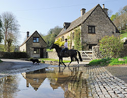
Duntisbourne Leer
| Duntisbourne Leer | |
| Gloucestershire | |
|---|---|
 Dustinbourne Leer Ford | |
| Location | |
| Grid reference: | SO975075 |
| Location: | 51°45’58"N, 2°2’13"W |
| Data | |
| Post town: | Cirencester |
| Postcode: | GL7 |
| Dialling code: | 01285 |
| Local Government | |
| Council: | Cotswold |
| Parliamentary constituency: |
The Cotswolds |
Duntisbourne Leer is a village in Gloucestershire, sitting amongst the Cotswolds some ten miles south-east of Gloucester and four and a half miles north-west of Cirencester. Nearby villages include Duntisbourne Abbots and Duntisbourne Rouse.
The village was recorded as Duntesborne in the Domesday Book, the name coming from the Old English for "Dunt's stream" after an otherwise unknown progenitor. The Domesday Book records that the hamlet then belonged to the Abbey of Lyre in Normandy, from which the village receives the suffix 'Leer'.[1]
Nutbeam Farmhouse in the village is a Grade II* listed building, dating in part from the 15th century, and part of the former monastic estate.
References
- ↑ Mills, A. D. (1998). Dictionary of English Place-Names. Oxford University Press. pp. 120. ISBN 0-19-280074-4.

This Gloucestershire article is a stub: help to improve Wikishire by building it up.