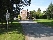
Badgeworth
| Badgeworth | |
| Gloucestershire | |
|---|---|
 The area by the church | |
| Location | |
| Grid reference: | SO904194 |
| Location: | 51°52’24"N, 2°8’25"W |
| Data | |
| Population: | 1,286 |
| Postcode: | GL51 |
| Dialling code: | 01452 |
| Local Government | |
| Council: | Tewkesbury |
| Parliamentary constituency: |
Tewkesbury |
Badgeworth is a village in Gloucestershire, found in the narrow rural gap between Gloucester and Cheltenham. The 2011 census recorded a population of 1,286.
Apart from the village of Badgeworth the parish also includes Bentham and Little Witcombe.
The Gloucestershire Way long-distance footpath runs through the village, and the Cheltenham Circular Footpath skirts its edge.
History
Despite its small size and being situated nearly a mile south of the line, in 1843 Badgeworth was provided with a station on the newly opened Birmingham and Gloucester Railway (later part of the Midland Railway), but this was a very early casualty, closing as early as 1846.
The Bentham Works site of Gloster Aircraft Company was built north of the A417 in 1941.
Pictures
|
Outside links
| ("Wikimedia Commons" has material about Badgeworth) |
- Information on Badgeworth from GENUKI
- Badgeworth in the Domesday Book


