Newchurch, Kent
| Newchurch | |
| Kent | |
|---|---|
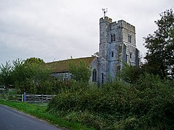
 Newchurch Church's leaning tower | |
| Location | |
| Location: | 51°2’42"N, 0°55’48"E |
| Data | |
| Population: | 315 (201)[1]) |
| Post town: | Romney Marsh |
| Postcode: | TN29 |
| Local Government | |
| Council: | Folkestone and Hythe |
| Parliamentary constituency: |
Folkestone and Hythe |
Newchurch is a village and parish in the Newchurch Hundred of Kent. The village is located on the Romney Marsh, three miles west of Dymchurch.
During the Second World War it was home to an RAF airfield, RAF Newchurch, that operated Hawker Tempest fighter aircraft under Wing Commander Roland Beamont which participated in the defence of the UK against the German V-1 flying bomb offensive of 1944. A Chain Home coastal radar station was also located there.
The parish church is dedicated to St Peter and St Paul.[2] The ecclesiastical parish forms part of the Romney Deanery of the Maidstone archdeaconry of the Diocese of Canterbury.
References
Outside links
| ("Wikimedia Commons" has material about Newchurch, Kent) |

This Kent article is a stub: help to improve Wikishire by building it up.
