Stone-in-Oxney
| Stone-in-Oxney | |
| Kent | |
|---|---|
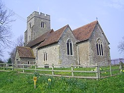
 St Mary's church | |
| Location | |
| Grid reference: | TQ939278 |
| Location: | 51°1’0"N, 0°45’55"E |
| Data | |
| Population: | 392 (2001 (inc. Ebony)) |
| Post town: | Tenterden |
| Postcode: | TN30 |
| Dialling code: | 01233 |
| Local Government | |
| Council: | Ashford |
| Parliamentary constituency: |
Ashford |
Stone in Oxney is a village and ancient parish in the hundred of Oxney in Kent, to the south of south of Ashford. It forms part of the civil parish of Stone-cum-Ebony near Appledore.
The village is 11 miles south-east of Tenterden, and stands in a position on the eastern side of the Isle of Oxney. The stone that gives the village its name is preserved in the village church, and is of Roman origin.[1] Often thought to be an altar of Mithras, it in fact depicts Apis.[2]
The Saxon Shore Way, a long distance walking route tracing the old Saxon shoreline, passes through the parish.
References
| ("Wikimedia Commons" has material about Stone-in-Oxney) |

This Kent article is a stub: help to improve Wikishire by building it up.
