Kenchester
| Kenchester | |
| Herefordshire | |
|---|---|

| |
| Location | |
| Grid reference: | SO437428 |
| Location: | 52°4’53"N, 2°49’19"W |
| Data | |
| Post town: | Hereford |
| Postcode: | HR4 |
| Local Government | |
| Council: | Herefordshire |
| Parliamentary constituency: |
North Herefordshire |
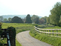
Kenchester is a hamlet in Herefordshire, in the valley of the River Wye, upstream of Hereford and about five and a half miles west.
History
Kenchester is near the site of the Romano-British town of Magnae Dobunnorum.[1] and was once part of the early English Kingdom of the Magonsæte, which possibly took its name from Magnae

Parish church
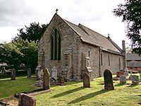
The Church of St Michael is a Grade I listed building.[2]
Outside links
| ("Wikimedia Commons" has material about Kenchester) |
References
- ↑ "Herefordshire Through Time - Magnis". Herefordshire Council. http://www.herefordshire.gov.uk/htt/1325.aspx. Retrieved 2010-08-21.
- ↑ National Heritage List 1172691: Church of St Michael, Kenchester
