Hentland
| Hentland | |
| Herefordshire | |
|---|---|
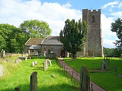
 St Dubricius' Church, Hentland | |
| Location | |
| Grid reference: | SO542265 |
| Location: | 51°56’6"N, 2°39’54"W |
| Data | |
| Population: | 436 (2011) |
| Post town: | Ross-on-Wye / [Hereford |
| Postcode: | HR9 / HR2 |
| Dialling code: | 01989 / 01432 |
| Local Government | |
| Council: | Herefordshire |
| Parliamentary constituency: |
Hereford and South Herefordshire |
Hentland is a hamlet in Herefordshire, about five miles north-west of Ross-on-Wye.
The name 'Hentland' derives from the Old Welsh Hên-llan, meaning "old church-enclosure".
This is a little place. It has a parish church, St Dubricius, derives its dedication from the foundation of the village by that early monastic saint.
North of the hamlet flows the River Wye, which bounds the parish on the east: also within the parish are the villages of Hoarwithy and St Owen's Cross, and the hamlets of Gillow, Kynaston, Little Pengethley, Llanfrother and Red Rail. The area is mostly farmland, with a small proportion being woodland. The soil consists of red loam, with a subsoil of rock and clay.
Hentland wais the site of an early Welsh monastery, built by Saint Dubricius in the 6th century, which probably stood in the field just south of the present parish church
Gillow Manor is a 14th-century manor house with part of its moat still surviving; in the Middle Ages it was one of the homes of the Pembridge family of Herefordshire.
Outside links
| ("Wikimedia Commons" has material about Hentland) |
- The Parish Churches of Hentland & Hoarwithy
- Church and Community Website
- Landscape Origins of the Wye Valley - Tresseck & Altbough, Hentland
References
- Nikolaus Pevsner: The Buildings of England: Herefordshire, 1963; 2012 Penguin Books ISBN 978-0-300-12575-7page 144
