Donnington, Herefordshire
| Donnington | |
| Herefordshire | |
|---|---|
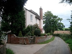
 Lane at Lower House, Donnington | |
| Location | |
| Grid reference: | SO708342 |
| Location: | 52°0’22"N, 2°25’31"W |
| Data | |
| Post town: | Ledbury |
| Postcode: | HR8 |
| Dialling code: | 01531 |
| Local Government | |
| Council: | Herefordshire |
| Parliamentary constituency: |
North Herefordshire |
Donnington is a village in Herefordshire, near Ledbury.
Parish church

The parish church is dedicated to St Mary.[1]
About the village
Donnington Hall is located here on the outskirts of the village.
In 1870-72, Donnington was described as:
- "DONNINGTON, a parish in Ledbury district, Hereford; under the Malvern hills, at the boundary with Gloucester, 2¼ miles S of Ledbury town and r[ailway]. station. Post town, Ledbury. Acres, 808. Real property, £1, 566. Pop[ulation]., 105. Houses, 20. The property is divided among a few. The living is a rectory in the diocese of Hereford. Value, £209.* Patron, R. Webb, Esq. The church is old but good; and has a wooden tower."[2]
Outside links
| ("Wikimedia Commons" has material about Donnington, Herefordshire) |
References
- ↑ St Mary, Donnington - a church near you
- ↑ Wilson, John Marius (1870). Imperial Gazetteer of England and Wales. Edinburgh: A. Fullerton & Co.. http://www.visionofbritain.org.uk/place/2426. Retrieved 27 January 2015.
