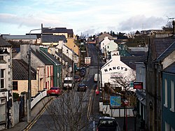
Ardara
| Ardara Irish: Ard an Rátha | |
| County Donegal | |
|---|---|
 Front Street, Ardara | |
| Location | |
| Grid reference: | G730905 |
| Location: | 54°45’42"N, 8°25’11"W |
| Data | |
| Population: | 731 (2011) |
| Postcode: | F94 |
| Local Government | |
| Website: | www.ardara.ie |
Ardara is a small town in County Donegal, located on the N56 and R261 roads. The community has a population of 731, per the 2011 Census, an increase of about 30% since 2006.
Scenic points near the town include the Glengesh Pass, the Maghera Falls and the views out over the Atlantic from Loughros Point. In 2012, The Irish Times named it the best village in which to live in Ireland.[1]
The name of the village is from the Irish Ard an Rátha, meaning 'Height of the fort'[2]
Pictures
-
Looking down south at Front Street in Ardara
-
Kilclooney dolmen near Ardara
-
Glengesh Pass looking through glacial valley into Ardara
Outside links
| ("Wikimedia Commons" has material about Ardara) |
References
- ↑ "'Best place is where you and your family flourish'". The Irish Times. June 18, 2012. https://www.irishtimes.com/news/best-place-is-where-you-and-your-family-flourish-1.1066903. Retrieved 3 March 2018.
- ↑ Ard an Rátha/Ardara – Placenames Database of Ireland


