Upton, Kent
| Upton | |
| Kent | |
|---|---|
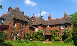
 The Red House in Upton | |
| Location | |
| Grid reference: | TQ485755 |
| Location: | 51°27’32"N, -0°8’10"E |
| Data | |
| Post town: | Bexleyheath |
| Postcode: | DA6 |
| Dialling code: | 020 |
| Local Government | |
| Council: | Bexley |
| Parliamentary constituency: |
Bexleyheath and Crayford |
Upton is an area which was once a village in itself in western Kent and now effectively part of Bexleyheath, within the edge of the metropolitan conurbation.
This was a mere hamlet until was engulfed when the new town of Bexleyheath developed during the early 20th century.
The most noteworthy building in Upton is Red House, an elegant brick and tile home designed by Philip Webb for William Morris in the Arts and Crafts style, now preserved by the National Trust. Upton also had a hospital that can still be seen on Upton Road in Bexleyheath.

This Kent article is a stub: help to improve Wikishire by building it up.