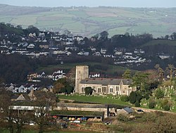
Wolborough
| Wolborough | |
| Devon | |
|---|---|
 St Mary's church, Wolborough | |
| Location | |
| Grid reference: | SX857703 |
| Location: | 50°31’20"N, 3°36’49"W |
| Data | |
| Post town: | Newton Abbot |
| Postcode: | TQ12 |
| Local Government | |
Wolborough is a village in Devon which has became no more than a suburb of the large town of Newton Abbot, Wolborough being seamlessly appended to the southern edge of the town.
The parish church, St Mary,[1] stands apart, at the western edge of the village. The present church dates from the 14th century with additional work in the 15th and 16th centuries. It stands though on the site of an earlier church mentioned in the Domesday Book of 1086. The font is Norman, thought to have come from the earlier church. The church also contains an interesting late-15th century lectern, one of about fifty known to exist in this country, which is said to have been hidden in Bradley Woods during the Civil War.
References
- ↑ St Mary, Wolborough – Newton Abbot Benefice