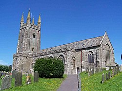
West Alvington
| West Alvington | |
| Devon | |
|---|---|
 All Saints, West Alvington | |
| Location | |
| Grid reference: | SX723438 |
| Location: | 50°16’50"N, 3°47’34"W |
| Data | |
| Local Government | |
| Council: | South Hams |
West Alvington is a small village on the western outskirts of Kingsbridge in the south of Devon on the A381 road, separate but just a ten-minute walk from the centre of Kingsbridge.
The village has a church and a primary school.
History
West Alvington was originally part of the manor of Bowringsleigh, which village took its name from the Bowring family, who were lords of the manor from about 1330 to the early sixteenth century. At one time, Alvington was part of the Royal Estates.[1] The town of Kingsbridge is a later creation from these royal estates, forming around a bridge which was built in or before the 10th century between the royal estates of Alvington, to the west, and Chillington, to the east, giving it the name of Kyngysbrygge ("King's bridge").
References
- ↑ "History of "West Alvington"". West Alvington Parish Council. http://westalvingtonpc.co.uk/4.html. Retrieved 2 January 2013.