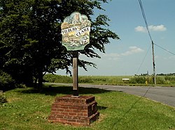
Tilbury-juxta-Clare
| Tilbury-juxta-Clare | |
| Essex | |
|---|---|
 Tilbury Juxta Clare village sign | |
| Location | |
| Grid reference: | TL761404 |
| Location: | 52°2’4"N, 0°33’59"E |
| Data | |
| Population: | 205 (2011[1]) |
| Post town: | Halstead |
| Postcode: | CO9 |
| Dialling code: | 01787 |
| Local Government | |
| Council: | Braintree |
| Parliamentary constituency: |
Saffron Walden |
Tilbury-juxta-Clare is a village and parish in Essex, close to the border with Suffolk. The descriptive "juxta Clare" is necessary to distinguish this Tilbury from the port of Tilbury in the south of the county. It is part of the Stour Valley North parish cluster.[2] The church, dedicated to St Margaret, dates back to the 15th century and linked to the De Vere estate at this time. The population quoted includes Ovington.
References
- ↑ "Civil Parish population 2011". Neighbourhood Statistics. Office for National Statistics. http://www.neighbourhood.statistics.gov.uk/dissemination/LeadKeyFigures.do?a=7&b=11129704&c=Tilbury+Juxta+Clare&d=16&e=62&g=6423025&i=1001x1003x1032x1004&o=362&m=0&r=1&s=1473100322672&enc=1. Retrieved 5 September 2016.
- ↑ "Parish cluster map" (JPG). www.braintree.gov.uk. https://web.archive.org/web/20061014102407/http://www.braintree.gov.uk/NR/rdonlyres/8095EE77-2A1C-41DB-984D-CC05F89C25B1/0/parishclustermap2005.jpg. Retrieved 2007-01-16.
Outside links
| ("Wikimedia Commons" has material about Tilbury-juxta-Clare) |

This Essex article is a stub: help to improve Wikishire by building it up.
