Watermillock Common
| Watermillock Common | |||
| Cumberland | |||
|---|---|---|---|
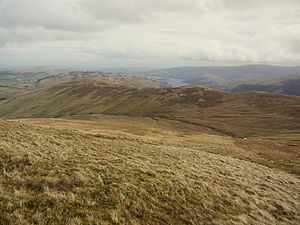
 Watermillock Common seen from Birkett Fell | |||
| Range: | Lake District Eastern Fells | ||
| Summit: | 1,814 feet NY379197 54°34’9"N, 2°57’41"W | ||
Watermillock Common is a ridge of high land which rises 1,312 feet above Ullswater in Cumberland. It is the end part of one of the long eastern ridges of Stybarrow Dodd, and lies 656 feet lower than the Hart Side part of the ridge, of which it may be considered a subsidiary top.
This part of the ridge runs roughly north-east for about 1¾ miles from the Brown Hills at the foot of Hart Side. The ridge is drained on its northern and eastern sides by Aira Beck, while its south-eastern slopes drain directly into Ullswater. Aira Beck has cut a steep gorge between Watermillock Common and Gowbarrow Fell, which continues the line of high ground further east.
Summits
The highest point on Watermillock Common is Swineside Knott, 1,814 feet, a rounded grassy mound but with some rocks protruding, especially on its steep eastern side. Swineside Knott has what has been claimed to be “the most sumptuous view” of Ullswater;[1] certainly it is the most extensive view, from the head of the lake (and the fells on either side of Patterdale beyond that) all the way down to the foot of the lake at Pooley Bridge.
Common Fell at 1,811 feet is only three feet lower than Swineside Knott, but is more centrally placed on the ridge and so feels more like its natural summit. It consists of a number of rounded grassy mounds. A small cairn has been built on the highest one, but a remarkable glacial erratic boulder is perched on one of the other mounds. Common Fell gives good views to the north and east.
Two lower tops at the east end of the ridge are Round How (1,270 feet) and Bracken How (1,214 feet), both rounded grassy mounds punctuated with some rock and with small cairns on top.
Geology
The oldest rocks found on the Watermillock Common ridge occur on the lower south-eastern slopes (above Ullswater) where faulting has brought to the present surface an inlier of mudstone from the 'Tarn Moor Formation', the latest part of the Skiddaw Group. These mudstones were deposited in deep seas about 470 million years ago during the Ordovician period.
The remainder of the ridge consists of andesite rocks of the Birker Fell Andesite Formation'. These rocks are a succession of sheets of andesite lava flows which came from shallow-sided volcanoes. Here and there the map shows beds of volcaniclastic sandstone or breccia, sedimentary deposits formed from the erosion of the volcanic rocks. Around the summit of Common Fell it shows areas of hyaloclastite, a rock made up of shattered angular fragments and formed by the quenching of lava in water. However, smooth grassy turf covers these rocks from view.
Ascent
Apart from the lower slopes beside Aira Beck, around Dockray and alongside Ullswater, Watermillock Common is Open Access land. Paths across the common begin from the village of Dockray and from the two car parks on the A5091 road.
One writer has claimed the ridge top near Common Fell "can be more of a wade than a walk",[1] but this was not found to be so early in 2014 after an unusually wet winter.