East Worlington
| East Worlington | |
| Devon | |
|---|---|
 St Mary's, East Worlington | |
| Location | |
| Grid reference: | SS774137 |
| Location: | 50°54’36"N, 3°44’39"W |
| Data | |
| Post town: | Crediton |
| Postcode: | EX17 |
| Local Government | |
East Worlington is a hamlet in north-eastern Devon, on the north side of the Little Dart River, upstream of its sister hamlet, West Worlington, and two miles west of Witheridge, the only nearby village of any size.
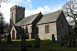
Though small, East Worlington has a village church (as does West Worlington, both in the same parish). The church, St Mary, is a modest church with a crenelated tower. It is predominantly a 15th century church, though tower is of the 13th century and chancel partly of the 14th. The church underwent a Victorian restoration.[1]
Outside links
| ("Wikimedia Commons" has material about East Worlington) |
References
- ↑ National Heritage List 1107298: Church of St Mary