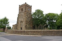
Church, Lancashire
| Church | |
| Lancashire | |
|---|---|
 St James' Church, Church Kirk | |
| Location | |
| Grid reference: | SD746288 |
| Location: | 53°45’18"N, 2°23’10"W |
| Data | |
| Population: | 5,186 (2011[1]) |
| Post town: | Accrington |
| Postcode: | BB5 |
| Dialling code: | 01254 |
| Local Government | |
| Council: | Hyndburn |
| Parliamentary constituency: |
Hyndburn |
Church is a village and township in Lancashire, situated a mile west of Accrington. The village built-up area had a population of 3,990 according to the 2001 census, increasing to 5,186 at the 2011 Census.[lower-alpha 1][2][1] The main road running through the village is the A679, with Church and Oswaldtwistle railway station located less than a mile from the village centre. Church is one of the townships of the extensive ancient parish of Whalley.
The parish church is the Church of St James, which has a late-mediæval tower (damaged by fire in 1983) and a nave constructed in 1805.
Church's most famous son was Edward Ormerod or Ormrod (1834-1894), inventor in 1867 of the patent Ormerod Butterfly Clip, which has been responsible for saving the lives of generations of coal miners.
Facilities
Church has a Lidl supermarker, a KFC, a bakery (Yates'), a Coral bookmakers, a Texaco, a sports centre which opened in 1977, a fire station, a Howarth Timber, a car sales/tyres centre, a motorstore/bike shop, an appliance repair/sales, a chippy, and an Italian restaurant.
A small library, Church Library, was located in the village, but it closed during 2006.
Church is the halfway point on the Leeds and Liverpool Canal.
Education
Church is home to St Christopher's Church of England High School, Accrington Academy and St Nicholas C.E. Primary School.
References
Notes
- ↑ The area in 2001 was listed as 277 acres, whereas in 2011 it was 327 acres.
Citations
- ↑ 1.0 1.1 UK Census (2011). "Local Area Report – Church Built-up area (1119883746)". Nomis. Office for National Statistics. https://www.nomisweb.co.uk/sources/census_2011_ks/report?compare=1119883746. Retrieved 8 February 2018
- ↑ Lancashire Profile
Outside links
| ("Wikimedia Commons" has material about Church, Lancashire) |
