Little Canfield
| Little Canfield | |
| Essex | |
|---|---|
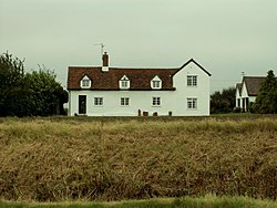
 Red Barn farmhouse near Little Canfield | |
| Location | |
| Location: | 51°52’7"N, -0°16’28"E |
| Data | |
| Post town: | Dunmow |
| Postcode: | CM6 |
| Dialling code: | 01279 |
| Local Government | |
| Council: | Uttlesford |
Little Canfield is a village and parish in the Dunmow hundred of Essex. The village is situated the B1256 road, near the A120 road and contiguous with the village of Takeley. It is uncomfortably close to the south-east perimeter of Stansted Airport.
The village expanded in the early 21st century as new housing developments were built in the area. It has a public house, the Lion and Lamb.
Outside links
| ("Wikimedia Commons" has material about Little Canfield) |
- "Listed Buildings in Little Canfield, Essex, England", British Listed Buildings
- "Little Canfield", Recordinguttlesfordhistory.org.uk, United Kingdom Individual registrant web site

This Essex article is a stub: help to improve Wikishire by building it up.
