Boddington, Northamptonshire
| Boddington | |
| Northamptonshire | |
|---|---|
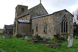
 St John the Baptist parish church, Upper Boddington | |
| Location | |
| Grid reference: | SP4752 |
| Location: | 52°10’8"N, 1°18’25"W |
| Data | |
| Population: | 700 (2011) |
| Post town: | Daventry |
| Postcode: | NN11 |
| Dialling code: | 01327 |
| Local Government | |
| Council: | West Northamptonshire |
| Parliamentary constituency: |
Daventry |
| Website: | The Boddingtons |
Boddington is a parish in Northamptonshire, about five miles north-east of Banbury off the A361 road.
The parish includes the villages of Upper Boddington and Lower Boddington. Upper Boddington is the larger of the two, on a hill close to the tripoint of Northamptonshire, Oxfordshire and Warwickshire, with Lower Boddington on the southern slope of the hill. Nearby Boddington Reservoir is used for sailing and recreational fishing.
Demographics
According to the 2001 census it had a population of 700,[1] rising to a 2010 estimate of 722: 280 in Lower Boddington and 442 in upper Boddington).[2]
History
Boddington was almost certainly founded in Anglo-Saxon times.[3] The spelling of Boddington has changed over the centuries. In the Domesday Book it is given as Botendon.[4] A survey of Northamptonshire from the 12th century gives the name as Bottelendon, while The Calendar of Close Rolls from 1244 states the name as Budinton. Documents from 1358, 1396 and 1428 give the names as Botyngdon, Botyndoun and Botyngdon respectively. Some 19th-century maps name the parish Bodington, with only one "d". Ideas concerning the origin of the name vary greatly; the Oxford Dictionary of English Place-names says that it is derived from "The hill of a man called Bota".[4]
The two villages of Upper and Lower Boddington may have been separate in their early history, but were officially merged into a single parish by an Act of Parliament in 1758. The population of the village can be traced back through the national censuses as far back as 1801. In the 19th century, the population appears to have fluctuated considerably, rising from 476 in 1801 to 926 in 1851, then declining to 487 by 1901. The 2001 census gives the population of the parish as 700.[5]
In 1870, following the passing of the first Education Act, the Rev. Edward Sale began an effort to build a local school. Boddington C of E Primary school was built on church land at a cost of £718. The school remains in use today, with recent extension work providing it with modern sports and information technology facilities.
Buildings
During World War I the parish hosted Belgian refugees. During World War II, on 25 November 1944, a Vickers Wellington bomber crashed into the Manor House, killing three people in the house and the seven crew of the plane, and severely damaging the upper storey of the building.[6] The house has only recently been re-roofed.
The parish contains many old listed buildings. Opinions vary as to which house is the oldest in the village. Some books on the village claim that Cherry Tree House is the oldest, though, architecturally, the house appears to be approximately the same age as Stoneleigh Farm, situated opposite it, and the Plough Inn.
Church and chapel
The Church of England parish church of Saint John the Baptist in Upper Boddington includes two tomb recesses dating from about 1300.[7] The chancel windows and the south window of the south transept are Decorated Gothic.[7] The west tower is Perpendicular Gothic and the south porch was added in 1629.[7]
North of St. John's is the Old Rectory, which was built in 1680 and had a third storey added in the 19th century.[7] It is an ironstone building of five bays.[7]
Upper Boddington has also a Methodist chapel that was built in 1865.
Amenities
The parish has a number of community facilities and businesses, mostly in Upper Boddington. The church, the Methodist Chapel, Post Office, the Plough Inn, a village hall and a primary school. The Village Garage, specialising in classic cars, opened in 2007. A photographic studio and a web design company are also in the garage building.[8]
Boddington Reservoir is used for local and competition fishing[9] and is also the base of Banbury Sailing Club.[10] Local activities range from darts and skittles leagues at the Plough Inn, badminton matches and annual quizzes at the Village Hall, a 6-a-side football team playing in Napton and a classic car get-together every first Sunday of the month at the Village Garage.
References
| ("Wikimedia Commons" has material about Boddington, Northamptonshire) |
- ↑ National Ststistics, published 28 April 2004, accessed 2 April 2010
- ↑ South Northamptonshire Council Year Book 2010-2011. Towcester: South Northamptonshire District Council. 2010. pp. 39.
- ↑ The Boddingtons Retrieved 6 November 2009
- ↑ 4.0 4.1 Mills, A.D. (1998), A Dictionary of English Place-names. Second Edition. Oxford University Press, Oxford, p, 44, ISBN 0-19-280074-4
- ↑ Office for National Statistics: Boddington CP: Parish Headcounts. Retrieved 6 November 2009
- ↑ The crash of LN242 Retrieved 6 November 2009
- ↑ 7.0 7.1 7.2 7.3 7.4 Pevsner & Cherry, 1973, page 437
- ↑ The Village Garage: About Us Retrieved 6 November 2009
- ↑ Fisheries.co.uk: Boddington Reservoir. Retrieved 6 November 2009
- ↑ Banbury Sailing Club. Retrieved 6 November 2009
- The Parish of Boddington: History, Information and Directory (10th ed.). 2004.
- Pevsner, Nikolaus; Cherry, Bridget (1973) [1961]. Northamptonshire. The Buildings of England. Harmondsworth: Penguin Books. p. 437. ISBN 0-14-071022-1.
