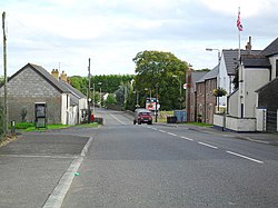
Stoneyford, County Antrim
| Stoneyford | |
| County Antrim | |
|---|---|
 Stoneyford Village | |
| Location | |
| Grid reference: | J216702 |
| Location: | 54°34’1"N, 6°7’16"W |
| Data | |
| Post town: | Lisburn |
| Postcode: | BT28 |
| Local Government | |
| Council: | Lisburn and Castlereagh |
Stoneyford is a small village in County Antrim, found between Glenavy and Milltown, about five miles north of Lisburn. The Stoneyford River flows through the village from the east to Lough Neagh.
The 2001 census had a population of 318.
Development extends along both sides of Stoneyford Road, which runs through the village on a north/west to south/east axis. Four other minor roads meet Stoneyford Road on the western edge of the village where the landscape of the surrounding countryside is characterised by marshy low-lying fields and low, gently undulating hills. Stoneyford originated as a small linear settlement, situated beside a fording point on a river, which gives the place its name.
Buildings of interest include the parish church, St John's, and a pre-1830 two-story dwelling on Stoneyford Road.
The building of St John’s Church in the 19th century extended the settlement to the south-east. The construction of the Stoneyford Reservoir greatly changed the character of lands to the south of the settlement, and the reservoir is now an important feature of the village.
Parish chuch
St John’s Church was built in the nineteenth century, at some time before 1850. It is a listed building.
Places of interest
The village is directly north of Stoneyford Reservoir, a popular angling spot for rainbow trout and brown trout.[1]
Outside links
| ("Wikimedia Commons" has material about Stoneyford, County Antrim) |
