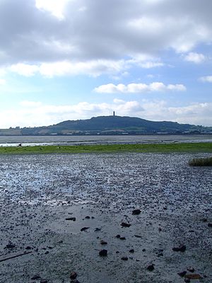
Scrabo Hill
| Scrabo Hill | |
| County Down | |
|---|---|
 Scrabo Hill from Strangford Lough | |
| Summit: | 525 feet J477726 54°34’49"N, 5°42’56"W |
Scrabo Hill is a hill of just 525 feet but rising dramatically in the low landscape, standing in the north of County Down, at the head of Strangford Lough and by Newtownards.
The Scrabo Tower stands atop the hill – a vast memorial, 135 feet high, to Charles William Stewart, 3rd Marquis of Londonderry, known as "Fighting Charlie" for his service during the Peninsular War and at Waterloo, though equally commemorating his work alleviating the hardship of the Great Famine. It was built to the design of Charles Lanyon in 1857 and financed by local people.
Scrabo Hill is an 'Area of Outstanding Natural Beauty' and is part of the Scrabo Country Park. The view from the hill is exceptional, extending across Strangford Lough to the Mourne Mountains, the Isle of Man and Wigtownshire.
Archaeology
There are signs of habitation on the hill from the Mesolithic Age, the Bronze Age and the Iron Age. The density and number of hut circles and the remains of an extensive hill fort indicate that it may have been one of the largest communal settlements in Ireland.
This is a sandstone hill, and has been quarried in a number of places.
Outside links
| ("Wikimedia Commons" has material about Scrabo Hill) |
