Threlkeld
| Threlkeld | |
| Cumberland | |
|---|---|
 Blease Gill | |
| Location | |
| Grid reference: | NY3125 |
| Location: | 54°37’9"N, 3°3’5"W |
| Data | |
| Population: | 423 (2011[1]) |
| Post town: | Keswick |
| Postcode: | CA12 |
| Dialling code: | 017687 |
| Local Government | |
| Council: | Westmorland & Furness |
| Parliamentary constituency: |
Penrith and The Border |
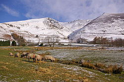
Threlkeld is a village and civil parish in Cumberland, to the east of Keswick. It lies at the southern foot of Blencathra, one of the more prominent fells in the northern Lake District, and to the north of the River Glenderamackin. The civil parish corresponds to the chapelry of the ancient parish of Greystoke.
Overview
Threlkeld formerly had its own railway station on the Cockermouth, Keswick and Penrith Railway, on the opposite side of the valley, next to the (closed) Threlkeld Quarry, at the foot of Clough Head. Today the railway line is a footpath and cycle track. Three rows of terraced houses, which used to accommodate the quarry workers, stand near the station. The Threlkeld Quarry and Mining Museum is open nearby and operates the 2ft narrow-gauge[2] Threlkeld Quarry Railway for tourists to enjoy.
Two pubs are located opposite each other in the village: The Salutation and the Horse and Farrier. There is also a Coffee Shop, a vibrant Village Hall, and a small church, St Mary's, in the village.
References
Outside links
| ("Wikimedia Commons" has material about Threlkeld) |
- Threlkeld village website - Threlkeld Web is run for the Parish Council and runs alongside the "Beneath Blencathra" newsletter.
- Threlkeld Village Hall website - Village Hall and Coffee Shop website
- Threlkeld village website
- Threlkeld Village - history and pictures from the Threlkeld CE Primary School website
- Saddleback Slate - Threlkeld Quarry slate manufacturing company
- Threlkeld Quarry & Mining Museum - official website
