Ore, Sussex
| Ore | |
| Sussex | |
|---|---|
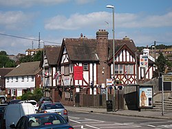
 The Oddfellows Arms, Ore | |
| Location | |
| Grid reference: | TQ836113 |
| Location: | 50°52’20"N, 0°36’31"E |
| Data | |
| Population: | 5,195 (2011) |
| Post town: | Hastings |
| Postcode: | TN34, TN35 |
| Dialling code: | 01424 |
| Local Government | |
| Council: | Hastings |
| Parliamentary constituency: |
Hastings and Rye |
Ore is a village on the south coast of Sussex which has become in effect a suburb of Hastings, though retaining an identity of its own. Ore is to be found just over a mile north-east of Hastings itself, on the main road to Rye (the coastal A259 road).
The name 'Ore' may have originated from the Old English word ora, meaning a "stream-bank".[1] The Ore Stream still runs through a large central Woodland area known locally as Speckled Wood, Hastings at the top of the Valley.
Ore Valley lies to the west of Ore Village, and is the site of Ore Railway Station and the former Broomgrove power station. It is also the site of a proposed major redevelopment and housing project.
Churches
Churches in the village are:
- Church of England:
- Christ Church
- St Helens
- Methodist
- Salvation Army
- Seventh-day Adventist Church
The part of Ore containing St Helen's Church is itself known as 'St Helens'. Today's church was built in 1868, and its predecessor, an ancient church dating from the reign of Edward III, now stands in ruins nearby. Hastings Cemetery is in the St Helens area of Ore.
Rail transport
Ore Railway Station (one mile from Ore main street/Ore Village) lies on the Marshlink Line; with the maintenance depot for the trains from London, and the coast (via the East Coastway Line and Hastings Line). Ore station lies northeast of Hastings station]] and south of Three Oaks (formerly Three Oaks and Guestling Halt).
References
- ↑ Roberts, R. G. (1914). The Place-Names of Sussex. Cambridge University Press. p.194.