Nettlecombe, Somerset
| Nettlecombe | |
| Somerset | |
|---|---|
 Nettlecombe Court | |
| Location | |
| Grid reference: | ST057378 |
| Location: | 51°7’53"N, 3°20’54"W |
| Data | |
| Population: | 174 (2011) |
| Post town: | Taunton |
| Postcode: | TA4 |
| Dialling code: | 01984 |
| Local Government | |
| Council: | Somerset West and Taunton |
| Parliamentary constituency: |
Bridgwater & W. Somerset |
Nettlecombe is village in Somerset, in a rural area below the Brendon Hills. It is a little place, the whole, wide parish with a population of 174 according to the 2011 census.
The village takes its name from Nettlecombe Court, an Elizabethan manor house which was once the manorial centre of the area.
There are no shops or other services within the parish, which is instead served by the nearby village of Williton.
Parish church
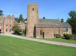
The Church of St Mary the Virgin dates from the thirteenth and fourteenth centuries, with further alterations since. It lies within the grounds of Nettlecombe Court, and has been designated as a Grade I listed building.[1]
History
The manor was held before the Norman Conquest by Godwin, son of King Harold, and subsequently was the property of the crown. In 1160 it was granted to Hugh de Ralph and has never been sold since. It passed down through the family to John Trevelyan in 1481 and is still held by his successors.[2]
Outside links
| ("Wikimedia Commons" has material about Nettlecombe, Somerset) |
References
- ↑ Images of England — details from listed building database (264787) Church of St Mary the Virgin
- ↑ Bush, Robin (1994). Somerset: The complete guide. Wimborne: The Dovecote Press Ltd. pp. 153–154. ISBN 1-874336-26-1.
