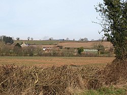
Copplestone, Tiverton
Not to be confused with Copplestone west of Crediton
| Copplestone | |
| Devon | |
|---|---|
 Copplestone | |
| Location | |
| Grid reference: | SS985125 |
| Location: | 50°54’11"N, 3°26’41"W |
| Data | |
| Post town: | Tiverton |
| Postcode: | EX16 |
| Local Government | |
Copplestone is a hamlet almost two miles east of Tiverton town centre in eastern Devon. It is on a minor road, West Manley Lane, just north of the old, dismantled railway branch line to Willand, now a footpath as far as Copplestone, and just north of the Grand Western Canal.
To the west, on West Manley Lane, is the site of a mediæval chapel of which no visible signs remain.