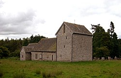
Michaelchurch-on-Arrow
| Michaelchurch-on-Arrow | |
| Radnorshire | |
|---|---|
 St Michael's | |
| Location | |
| Location: | 52°9’3"N, 3°5’56"W |
| Data | |
| Post town: | Kington |
| Postcode: | HR5 |
| Local Government | |
| Council: | Powys |
| Parliamentary constituency: |
Brecon & Radnorshire |
Michaelchurch-on-Arrow is an ancient parish in Radnorshire, adjacent to the border with Herefordshire. It lies within the Paincastle Hundred some five miles from Kington in the latter county. It is surrounded on three sides by Herefordshire: to the north and east by Huntington; and to the south by Brilley. The Radnorshire parishes of Newchurch and Colva lie to the east; with Gladestry to the north.
The parish derives its name from that of its church and its position on the River Arrow.
Parish church
The Church of England parish church has some mediæval fabric, probably dating from the 13th century. It was restored in 1869 by Thomas Nicholson, the diocesan architect of Hereford. There is a fine 15th-century screen and a pre-Reformation ciborium, probably unique in Wales. It forms part of the Diocese of Hereford.
Outside links
This Radnorshire article is a stub: help to improve Wikishire by building it up.