Caythorpe, Nottinghamshire
- Not to be confused with Caythorpe, Lincolnshire
| Caythorpe | |
| Nottinghamshire | |
|---|---|
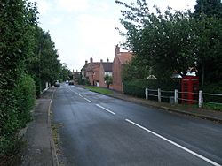
 Caythorpe's Main Street | |
| Location | |
| Grid reference: | SK688455 |
| Location: | 53°0’0"N, -0°58’48"W |
| Data | |
| Population: | 271 (2011) |
| Post town: | Nottingham |
| Postcode: | NG14 |
| Dialling code: | 0115 |
| Local Government | |
| Council: | Newark and Sherwood |
Caythorpe is a hamlet in Nottinghamshire, ten miles north-east of Nottingham and standing close to the River Trent. At the 2001 census it had a recorded population of 259.
The hamlet has a water mill dated 1749.[1] A windmill stood in a field called Fairholme, later Woolf's Farm. This may be the mill referred to in an advertisement in the Nottingham Review of 1851: "Excellent Windmill containing two pair French Stones, dressing machine etc., cottage, stable, outbuildings, 7 to 8 acres land in occupation of Mr. Arnold." This mill is reputed to have been sold and transferred to Epperstone.[2] A windmill site is shown on the First Series Ordnance Survey map (SK654458).
Outside links
| ("Wikimedia Commons" has material about Caythorpe, Nottinghamshire) |
References
- ↑ Nikolaus Pevsner: The Buildings of England: Nottinghamshire, 1951; 1979 Penguin Books ISBN 978-0-300-09636-1page 96
- ↑ Sharp, A.; O'Neill, J. (1992): Not Forgetting Caythorpe, Trent Valley Local History Group, Nottingham. p.31
