Little Bowden
| Little Bowden | |
| Northamptonshire | |
|---|---|
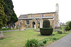
 St Nicholas' parish church | |
| Location | |
| Grid reference: | SP7887 |
| Location: | 52°28’30"N, -0°54’40"W |
| Data | |
| Post town: | Market Harborough |
| Postcode: | LE16 |
| Dialling code: | 01858 |
| Local Government | |
| Council: | Harborough |
| Website: | Little Bowden Society |
Little Bowden is an ancient parish in Northamptonshire that forms the southern part of Market Harborough, the northern part of which lies in Leicestershire. The River Jordan runs through part of the area.
Amenities
- Two pubs, The Cherry Tree and The Oat Hill (formerly The Greyhound)
- The 13th-century Church of England parish church of Saint Nicholas, which is part of the Diocese of Leicester.
- Little Bowden County Primary School
- Little Bowden Recreation Ground, which is the home ground of Harborough South Cricket Club.
Windy Ridge
Windy Ridge is a hill near Little Bowden. The area was often used for walks by local people. There were several attempts to build on Windy Ridge, all of which had been opposed by residents concerned by the effect development may have on the skyline and hazardous effects of battery landfill. However, the most recent proposal to build on this land was accepted by the council and is now completed.
The new estate built upon Windy Ridge is called Rockingham View
Further reading
- Lee, J.M.; McKinley, R.A. (1964). A History of the County of Leicestershire. Victoria County History. 5, Gartree Hundred. London: Oxford University Press for the University of London Institute of Historical Research. pp. 38–49, 133–153. http://www.british-history.ac.uk/vch/leics/vol5.
- Pevsner, Nikolaus; Williamson, Elizabeth; Brandwood, Geoffrey (1976) [1960]. Leicestershire and Rutland. The Buildings of England. Harmondsworth: Penguin Books.
Outside links
| ("Wikimedia Commons" has material about Little Bowden) |
- Little Bowden Society
- St Nicholas parish church webpage

This Northamptonshire article is a stub: help to improve Wikishire by building it up.
