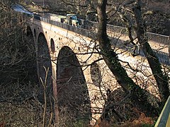
Pease Bridge
| Pease Bridge | |
| Berwickshire | |
|---|---|
 Pease Bridge | |
| Location | |
| Carrying: | A1107 |
| Crossing: | Pease Burn |
| Location | |
| Grid reference: | NT79156998 |
| Location: | 55°55’21"N, 2°20’7"W |
| Structure | |
| History | |
| Built 1786 | |
| Information | |
Pease Bridge crosses the Pease Burn and its valley, in Pease Dean, in north-eastern Berwickshire. It is to be found to the west of Old Cambus.
The bridge comprises four tall arches, it is 300 feet long, 16 feet wide, and 139 feet high, and the parapet is surmounted by an iron railing. The bridge was opened in 1786 and at that time it was the highest bridge in the world.
References
- SCRAN image:Pease Bridge
- CANMORE (RCAHMS) record of Pease Bridge
- Pease Bridge on Scotland's Places (RCAHMS)
- A1107: Reopening of Pease Bridge, 2004
