Drimpton
| Drimpton | |
| Dorset | |
|---|---|
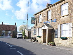
 The Royal Oak public house at Drimpton | |
| Location | |
| Grid reference: | ST418050 |
| Location: | 50°50’30"N, 2°49’39"W |
| Data | |
| Post town: | Beaminster |
| Postcode: | DT8 |
| Dialling code: | 01308 |
| Local Government | |
| Council: | Dorset |
| Parliamentary constituency: |
West Dorset |
Drimpton is a village in the parish of Broadwindsor in western Dorset, approximately five miles north-west of Beaminster and three and a half miles south-west of Crewkerne in neighbouring Somerset.
Drimpton is sited on a small tributary of the River Axe which was unnamed until 2005 when, after a vote by villagers, it was officially named the "Little Axe". Neighbouring settlements include Clapton, Seaborough, Broadwindsor, Burstock, Greenham and Netherhay, the latter two being small hamlets virtually contiguous with Drimpton. At Greenham there was once a flax mill, part of which still survives as a factory making pet products. The village has two places of worship: the Anglican parish church of St Mary's and the Netherhay Methodist chapel. Three books, chronicling life in the area, have recently been compiled; the project was called 'Village Voices'.
| ("Wikimedia Commons" has material about Drimpton) |
