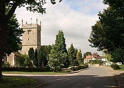
Sunningwell
| Sunningwell | |
| Berkshire | |
|---|---|
 Sunningwell | |
| Location | |
| Grid reference: | SP4900 |
| Location: | 51°42’4"N, 1°16’59"W |
| Data | |
| Population: | 1,554 (2001) |
| Post town: | Abingdon |
| Postcode: | OX13 |
| Dialling code: | 01865 |
| Local Government | |
| Council: | Vale of White Horse |
| Parliamentary constituency: |
Oxford West and Abingdon |
| Website: | Sunningwell Parish Council |
Sunningwell is a village in Berkshire a little to the north of Abingdon. The parish includes the village of Bayworth and the eastern part of Boars Hill.
It is close ot the main A34 Oxford to Newbury road, and consequently has felt the pressure of development, but Sunningwell has succeeded, after a campaign run by parishioners in warding off plans to develop Green Belt land surrounding the village.
The Flowing Well public house with beer garden is a well known destination for walkers.
Parish church
The parish church is St Leonard's. The church is largely 15th century with some earlier parts. The west porch is said to have been given by John Jewel, later Bishop of Salisbury, who was rector here in about 1551. There is a stained glass east window by J.P. Seddon, a friend of William Morris, who restored the church in 1877.[1] The church is a Grade II* listed building.[2]
Samuel Fell, chaplain to King James I, was rector here from 1625 to 1649.
Art school
Near the parish church is Sunningwell Art School.
Outside links
| ("Wikimedia Commons" has material about Sunningwell) |
References
- ↑ Pevsner, 1966, page 234
- ↑ Images of England website
Books
- Page, W.H.; Ditchfield, P.H., eds (1924). A History of the County of Berkshire, Volume 4. Victoria County History. pp. 423–427. http://www.british-history.ac.uk/report.aspx?compid=62743.
- Pevsner, Nikolaus (1966). Berkshire. The Buildings of England. Harmondsworth: Penguin Books. pp. 234–235.
