Wardley, Rutland
| Wardley | |
| Rutland | |
|---|---|
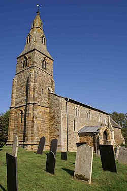
 St Botolph's Church | |
| Location | |
| Grid reference: | SK830003 |
| Location: | 52°35’42"N, -0°46’34"W |
| Data | |
| Population: | 32 (2001[1]) |
| Post town: | Oakham |
| Postcode: | LE15 |
| Dialling code: | 01572 |
| Local Government | |
| Council: | Rutland |
| Parliamentary constituency: |
Rutland and Melton |
Wardley is a village and parish in south-western Rutland, adjacent to the border with Leicestershire. The population at the 2001 census was 32. At the 2011 census the population remained less than 100 and is included in the parish of Ridlington. It is located about two miles west of Uppingham, close to the A47 road. The two-mile £1.9 million Wardley Hill Improvement opened in October 1987 when the road through the village became a dead end. The parish church is dedicated to St Botolph. In 2016 the church passed into the care of the Churches Conservation Trust.[2]
The village has no mains water supply, instead water is supplied from a borehole.[3]
Wardley Wood, owned by the Forestry Commission, is an ancient woodland on a hillside.[4]
| ("Wikimedia Commons" has material about Wardley, Rutland) |
References
- ↑ "Rutland Civil Parish Populations". Rutland County Council. 2001. http://www.rutland.gov.uk/ppimageupload/Image27657.PDF. Retrieved 21 March 2009.
- ↑ http://www.visitchurches.org.uk/latestnews/2016-04-14/Two-medieval-churches-in-the-East-Midlands-saved-by-the-Churches-Conservation-Trust/
- ↑ "Villagers lose mains water battle". BBC News. 16 June 2006. http://news.bbc.co.uk/1/hi/england/derbyshire/5086674.stm. Retrieved 22 March 2009.
- ↑ Forestry Commission; Wardley Wood

This Rutland article is a stub: help to improve Wikishire by building it up.
