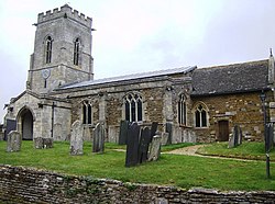
Belton-in-Rutland
| Belton-in-Rutland | |
| Rutland | |
|---|---|

| |
| Location | |
| Grid reference: | SK816014 |
| Location: | 52°36’0"N, -0°48’0"W |
| Data | |
| Population: | 335 (2001[1]) |
| Post town: | Oakham |
| Postcode: | LE15 |
| Dialling code: | 01572 |
| Local Government | |
| Council: | Rutland |
| Parliamentary constituency: |
Rutland and Melton |
Belton-in-Rutland is a village and parish in the county of Rutland. The population at the 2001 census was 345 increasing to 348 at the 2011 census.[2] It is situated about six miles south-west of Oakham and about four miles west of Uppingham and overlooks the A47 road.
The village has one Public House, The Sun Inn.
Belton was renamed Belton-in-Rutland in 1982 to distinguish the village from Belton in neighbouring Leicestershire.
References
- ↑ "Rutland Civil Parish Populations". Rutland County Council. 2001. http://www.rutland.gov.uk/ppimageupload/Image27657.PDF. Retrieved 30 January 2009.
- ↑ "Civil Parish population 2011". Neighbourhood Statistics. Office for National Statistics. http://www.neighbourhood.statistics.gov.uk/dissemination/LeadKeyFigures.do?a=7&b=11120588&c=belton-in-rutland+cp&d=16&e=62&g=6384716&i=1001x1003x1032x1004&m=0&r=1&s=1466762379047&enc=1. Retrieved 24 June 2016.
Outside links
| ("Wikimedia Commons" has material about Belton-in-Rutland) |

This Rutland article is a stub: help to improve Wikishire by building it up.
