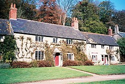
Stourton, Wiltshire
| Stourton | |
| Wiltshire, Somerset | |
|---|---|
 Cottages at Stourton | |
| Location | |
| Grid reference: | ST778341 |
| Location: | 51°6’22"N, 2°19’5"W |
| Data | |
| Post town: | Warminster |
| Postcode: | BA12 |
| Dialling code: | 01747 |
| Local Government | |
| Council: | Wiltshire |
| Parliamentary constituency: |
South West Wiltshire |
Stourton is a village and ancient parish on the borders of Wiltshire and Somerset. The village is about 8½ miles south of the market town of Frome in the latter county. It is part of the Stourhead estate, now in the ownership of the National Trust.
Two miles south-west are the earthwork remains of a motte-and-bailey castle known as Castle Orchard.
Buildings
The Church of England parish church of St Peter lies in the Wiltshire part of the parish. It has 14th-century origins but has been much restored and altered; it is Grade I listed.[1][2] It contains monuments of the Hoare family, owners of the estate. The architect and mason Nathaniel Ireson was churchwarden in the 1720s and may have done work on the church himself. The antiquarian William Coxe was rector from 1801 to 1811.
In the Somerset part of the parish lie the Grade II* listed Bonham House and cottage, dating from the 14th century.[3] A Roman Catholic chapel was here from 1559 until 1950.[4]
Amenities
There is a village hall[5] and a pub, the Spread Eagle Inn.[6]
Stourton is home to Kilmington and Stourton Cricket Club who play in Division One of the Somerset Cricket League.[7]
References
- ↑ National Heritage List 1318468: Church of St Peter, Stourton with Gasper
- ↑ "Church of St Peter, Stourton". Wiltshire Council. http://history.wiltshire.gov.uk/community/getchurch.php?id=1448. Retrieved 17 May 2015.
- ↑ National Heritage List 1131128: Bonham House and Bonham Cottage
- ↑ "Roman Catholic Church, Stourton". Wiltshire Council. http://history.wiltshire.gov.uk/community/getchurch.php?id=1449. Retrieved 17 May 2015.
- ↑ "Stourton Memorial Hall". http://www.stourtonmemorialhall.co.uk/. Retrieved 17 May 2015.
- ↑ "The Spread Eagle Inn". http://www.spreadeagleinn.com/. Retrieved 17 May 2015.
- ↑ "Kilmington and Stourton Cricket Club". http://www.kscc.org.uk/. Retrieved 17 May 2015.
Outside links
| ("Wikimedia Commons" has material about Stourton, Wiltshire) |
- "Stourton with Gasper". Wiltshire Council. http://history.wiltshire.gov.uk/community/getcom.php?id=215. Retrieved 17 May 2015.
- GENUKI - Stourton
