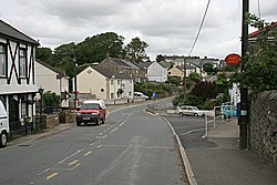
Grampound Road
| Grampound Road | |
| Cornwall | |
|---|---|
 Grampound Road | |
| Location | |
| Grid reference: | SW915505 |
| Location: | 50°19’1"N, 4°55’48"W |
| Data | |
| Local Government | |
| Council: | Cornwall |
Grampound Road is a village in the parish of Ladock in Cornwall, to be found two miles north-west of Grampound.
The village owes its foundation to the railway, and to Grampound Road Station, which was opened here on 4 May 1859. It closed in 1964 as part of the Beeching Axe. A small village known as Grampound Road grew up around the railway station and continues to expand despite the station's closing.[1]
References
- ↑ Cornwall Railway Gallery - Scorrier to Lostwithiel – Cornwall Railway Society