Furness Vale
| Furness Vale | |
| Cheshire | |
|---|---|
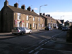
 The A6 passes through Furness Vale. | |
| Location | |
| Grid reference: | SK007835 |
| Location: | 53°20’56"N, 1°59’24"W |
| Data | |
| Population: | 1,500 |
| Post town: | High Peak |
| Postcode: | SK23 |
| Local Government | |
| Council: | High Peak |
| Parliamentary constituency: |
High Peak |
Furness Vale is a village in eastern Cheshire, adjacent to the border with Derbyshire. It is situated between New Mills in the latter county and Whaley Bridge. It is bisected by the A6 road and the Peak Forest Canal and has a population of approximately 1,500.[1]
Furness Vale railway station connects the village to Manchester.
References
| ("Wikimedia Commons" has material about Furness Vale) |

This Cheshire article is a stub: help to improve Wikishire by building it up.
