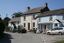
Chapel Amble
| Chapel Amble | |
| Cornwall | |
|---|---|
 Houses in Chapel Amble | |
| Location | |
| Grid reference: | SW997754 |
| Location: | 50°32’38"N, 4°49’44"W |
| Data | |
| Local Government | |
| Council: | Cornwall |
Chapel Amble is a village in the civil parish of St Kew, in northern Cornwall. It is to be found two miles north of Wadebridge next to the River Amble, a tributary of the River Camel.
The Cornish name Amaleglos means 'church on the river Amble'.
The main road through the village crosses the river on a stone bridge with high cutwaters. There is a shop and a single pub in the village.
History
The earliest written mention of Chapel Amble is in the Domesday Book where 'Amal' was held by Thurstan from Robert, Count of Mortain.[1]
The earliest record of the name "Amaleglos" is in 1284. The name "Amble" is derived from the Cornish "Amal", meaning "edge" or "boundary" and is the name of a tributary of the Camel. [2] As "eglos" is the Cornish for "church" there must already have been a chapel here; in 1383 a chapel of St Aldhelm was licensed.[3]
The Methodist chapel was a United Free Methodist chapel before the reunions of Methodist churches.[4]
Outside links
| ("Wikimedia Commons" has material about Chapel Amble) |
References
- ↑ "Cornwall A-K". The Domesday Book Online. domesdayonline.co.uk. http://www.domesdaybook.co.uk/cornwall1.html#bossiney. Retrieved 2010-11-25.
- ↑ Weatherhill, Craig (2009) A Concise Dictionary of Cornish Place-names. Westport, Mayo: Evertype
- ↑ Cornish Church Guide (1925) Truro: Blackford; p. 121
- ↑ Information on Chapel Amble from GENUKI
