Auldgirth
| Auldgirth | |
| Dumfriesshire | |
|---|---|
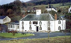
 The Auldgirth Inn on the A76 | |
| Location | |
| Grid reference: | NX912864 |
| Location: | 55°9’38"N, 3°42’32"W |
| Data | |
| Post town: | Dumfries |
| Postcode: | DG2 |
| Dialling code: | 01387 |
| Local Government | |
| Council: | Dumfries and Galloway |
Auldgirth is a village on the A76 road in Dumfriesshire.
'The Auldgirth Inn' stands beside the road in the village. This is a little place: apat fromthe inn there is a village shop, and once there was a primary school, which closed in 2000, and little else.
The name Auldgirth is from the Middle English / Old Scots ald(e) girþ, meaning 'old enclosure'.[1]
Once the village had a railway station, a proper manned one, a mile south of the village just before the hamlet of Dalswinton, though it has long since closed.
Carse Loch and the Friar's Carse country house hotel are located nearby.
References
- ↑ Williamson, May G. (1942). The Non-Celtic Place-names of the Scottish Border Counties. University of Edinburgh (Unpublished PhD Thesis). pp. 115. http://www.spns.org.uk/MayWilliamsonComplete.pdf#page=164.
| ("Wikimedia Commons" has material about Auldgirth) |
