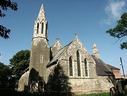
East Stockwith
| East Stockwith | |
| Lincolnshire | |
|---|---|
 St Peter's Church | |
| Location | |
| Grid reference: | SK795945 |
| Location: | 53°26’29"N, -0°48’8"W |
| Data | |
| Population: | 314 |
| Post town: | Gainsborough |
| Postcode: | DN21 |
| Dialling code: | 01427 |
| Local Government | |
| Council: | West Lindsey |
| Parliamentary constituency: |
Gainsborough |
East Stockwith is a village and civil parish in Lincolnshire, lying on the River Trent, three miles north-west of Gainsborough. The River Trent Aegir, a tidal bore, reaches the village. In 2001 it had a total resident population of 209,[1] increasing to 314 at the 2011 census.[2]
The hamlet of Walkerith, about a mile and a half to the south, is within East Stockwith parish.[3]
Opposite East Stockwith on the River Trent is West Stockwith, a large village within the county bounds of Nottinghamshire. The two villages were once connected by a ferry which stopped in 1953.[4]
The village contains a church, a pub, The Ferryman, and two large arable farms growing mainly wheat and potatoes. The nearest town with schools and shops is Gainsborough. Local leisure activities include angling on the Trent, particularly for eels, and horse riding.
References
- ↑ United Kingdom Census 2001. "East Stockwith CP (Parish)". neighbourhood.statistics.gov.uk. http://www.neighbourhood.statistics.gov.uk/dissemination/LeadDatasetList.do?a=7&b=796510&c=East+Stockwith&d=16&g=469158&i=1001x1003&m=0&enc=1&domainId=15. Retrieved 3 September 2007.
- ↑ "Civil parish population 2011". Neighbourhood Statistics. Office for National Statistics. http://www.neighbourhood.statistics.gov.uk/dissemination/LeadKeyFigures.do?a=7&b=11123012&c=East+Stockwith&d=16&e=62&g=6447814&i=1001x1003x1032x1004&m=0&r=1&s=1463392171362&enc=1. Retrieved 16 May 2016.
- ↑ "Walkerith". Vision of Britain. University of Portsmouth. http://www.visionofbritain.org.uk/relationships.jsp?u_id=10463294&c_id=10001043. Retrieved 21 August 2011.
- ↑ "East Stockwith". Lincolnshire County Council. http://parishes.lincolnshire.gov.uk/eaststockwith/. Retrieved 7 April 2013.
Outside links
| ("Wikimedia Commons" has material about East Stockwith) |
