Houstry
From Wikishire
Revision as of 20:55, 10 June 2016 by RB (Talk | contribs) (Created page with "{{Infobox town |name=Houstry |county=Caithness |picture=Wind farm at Houstry - geograph.org.uk - 543279.jpg |picture caption=Wind farm at Houstry |os grid ref=ND154350 |latitu...")
| Houstry | |
| Caithness | |
|---|---|
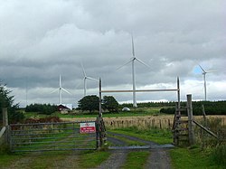
 Wind farm at Houstry | |
| Location | |
| Grid reference: | ND154350 |
| Location: | 58°17’44"N, 3°26’38"W |
| Data | |
| Postcode: | KW6 6 |
| Local Government | |
| Council: | Highland |
| Parliamentary constituency: |
Caithness, Sutherland and Easter Ross |
Houstry is a scattered crofting village, in the east coast of Dunbeath, Caithness.
A large wind farm has been built next to the village.
