Maypole, Isles of Scilly
From Wikishire
Revision as of 12:49, 4 April 2016 by RB (Talk | contribs) (Created page with "{{Infobox town |name=Maypole |county=Cornwall |picture=Cottage on The A3110 - geograph.org.uk - 821742.jpg |picture caption=Cottage on the A3110 road |os grid ref= |latitude=4...")
| Maypole | |
| Cornwall | |
|---|---|
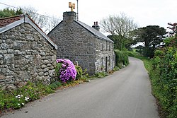
 Cottage on the A3110 road | |
| Location | |
| Location: | 49°55’35"N, 6°17’28"W |
| Data | |
| Post town: | Isles Of Scilly |
| Postcode: | TR21 |
| Dialling code: | 01720 |
| Local Government | |
| Council: | Isles of Scilly |
| Parliamentary constituency: |
St Ives |
Maypole is a dispersed village on the island of St Mary's, the largest of the Isles of Scilly, Cornwall. It is a tourist and farming area, with the only horse riding school in the islands.[1]
Nearby are Holy Vale and Pelistry. The A3110 road runs through the area; on this road to the west of Maypole, towards Telegraph, is Silver Carn or High Lanes, a hamlet which includes a large guesthouse and café.[2]
References
- ↑ ScillyOnline St Mary's Riding Centre
- ↑ Scilly Guest House