Thrapston
| Thrapston | |
| Northamptonshire | |
|---|---|
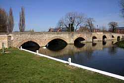
 Thrapston Bridge | |
| Location | |
| Grid reference: | SP997784 |
| Location: | 52°23’38"N, -0°32’6"W |
| Data | |
| Population: | 4,835 (2001) |
| Post town: | Kettering |
| Postcode: | NN14 |
| Dialling code: | 01832 |
| Local Government | |
| Council: | North Northamptonshire |
| Parliamentary constituency: |
Corby |
Thrapston is a small town in Northamptonshire, close to the River Nene.
The market charter was granted over 800 years ago, in the year 1205, in exchange for two palfreys. This is celebrated every year with the town's Charter fair, where the high street is closed and the people in the town get together to commemorate this event. Naturalist and writer Horace William Wheelwright practiced as an attorney in Thrapston in the 1840s.
The town is at the junction of the major A14 and the A45 roads. Until the 1960s, Thrapston had two railway stations; Thrapston (Midland) on the Kettering to Cambridge rout and Thrapston (Bridge Street) on the former London and North Western Railway Northampton to Peterborough line. The old Midland station and viaduct can be seen from the adjacent A14 road.
Parish church

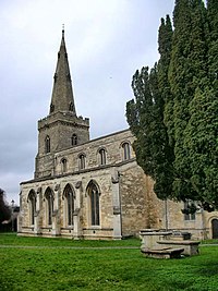
The parish church is the Church of St James. It was built in the 13th century, with additions since then.
Across the Nine Arches Bridge is St Nicholas Islip which dates from the 15th century, and a mile and a quarter along the River Nene in Denford is Holy Trinity Church, also of the 13th century; together these thre churches form a united benefice.
Sport
- Football: Thrapston Town FC

Outside links
| ("Wikimedia Commons" has material about Thrapston) |
References

This Northamptonshire article is a stub: help to improve Wikishire by building it up.
