Henshaw, Northumberland
| Henshaw | |
| Northumberland | |
|---|---|
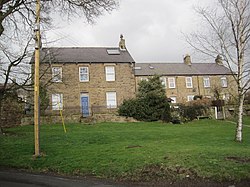
 Houses at Henshaw | |
| Location | |
| Grid reference: | NY765645 |
| Location: | 54°58’30"N, 2°22’8"W |
| Data | |
| Population: | 762 (2011) |
| Post town: | HEXHAM |
| Postcode: | NE47 |
| Dialling code: | 01434 |
| Local Government | |
| Council: | Northumberland |
| Parliamentary constituency: |
Hexham |
Henshaw is a small village in Northumberland, in the vicinity of Hadrian's Wall.
Local genealogy places the Cowings, Lambs, Robsons and Dickinsons as some of the families well known in this locale at least since the 19th century.[1]
See also
Outside links
| ("Wikimedia Commons" has material about Henshaw, Northumberland) |
References

This Northumberland article is a stub: help to improve Wikishire by building it up.
