Marshfield, Monmouthshire
| Marshfield | |
| Monmouthshire | |
|---|---|
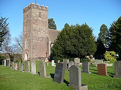
 St Mary's Church, Marshfield | |
| Location | |
| Grid reference: | ST275833 |
| Location: | 51°32’38"N, 3°2’49"W |
| Data | |
| Population: | 3,086 (2011) |
| Post town: | Cardiff |
| Postcode: | CF3 |
| Dialling code: | 01633 |
| Local Government | |
| Council: | Newport |
| Parliamentary constituency: |
Newport West |
Marshfield is a village and parish on the Wentloog level in south-west Monmouthshire. The parish contains the village of Castleton as well as Marshfield itself. It is considered to be an affluent and sought-after area.
The parish contains a Village Hall, post office and convenience store. There was formerly a railway station, an intermediate stop on the line between Newport and Cardiff, but it was closed in 1959.
Outside links
- www.geograph.co.uk : photos of Marshfield and surrounding area
- www.marshfieldcommunitycouncil.org.uk : Marshfield Community Council

This Monmouthshire article is a stub: help to improve Wikishire by building it up.