Cherry Hinton
| Cherry Hinton | |
| Cambridgeshire | |
|---|---|
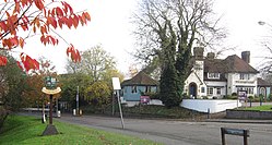
 Village entrance | |
| Location | |
| Grid reference: | TL487563 |
| Location: | 52°11’6"N, -0°10’34"E |
| Data | |
| Population: | 8,303 (2001) |
| Post town: | Cambridge |
| Postcode: | CB1 |
| Dialling code: | 01223 |
| Local Government | |
| Council: | Cambridge |
| Parliamentary constituency: |
Cambridge |
Cherry Hinton is a compact village in Cambridgeshire at the edge of the city of Cambridge. It is around four miles south-east of Cambridge city centre, separated from Cambridge by the grounds of Cherry Hinton Hall, the airfield and flooded gravel pits. To the south of the village the Gog Magog Hills rise up.
North of the village is Cambridge Airport and to the east is Fulbourn. To the South is Cherry Hinton Pit,[1] a nature reserve formed from old chalk pits and then the Gog Magog Hills which rise to 246 feet. Outside the residential area the land is open farmland, with relatively few trees.
The rectangular parish of Cherry Hinton occupies the western corner of Flendish Hundred.[2]
The village

In the High Street there are a number of shops including some national chains but mainly independents, along with such village amendities such as a pubs, takeaways and restaurants, hairdresser, a barber, a bakery, two pharmacies, a cycle shop, a craft shop, two bookies and a post office. There is also a Tesco superstore towards Fulbourn.
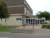
There is a village hall and sports leisure centre adjacent to the village library. The village has a well-appointed recreation ground situated on the high street. Here children's play equipment and football fields for local fixtures are provided. It also has a park and children's play area, including paddling pools and tennis courts, in the grounds of Cherry Hinton Hall, which hosts the internationally recognised annual Cambridge Folk Festival.
Parish church
The parish church is St Andrew's.
The church is of the 13th century, of Early English style and made of stone-faced fint rubble – the local clunch on which the villages hereabouts are built.[3]
History

The War Ditches at Cherry Hinton are the remains of an Iron Age hill fort where a massacre took place, now sadly mostly lost to quarrying.[4][5]
Cherry Hinton's entry in the Domesday Book of 1086 says:
"Hintone: Count Alan. 4 mills."[6] (Alan Rufus ‘the Red’, one of the Counts of Brittany, confiscated Hinton Manor from Edith, Harold II of England's common law wife, Edith Swanneck).
Fulbourn Hospital, to the East of Cherry Hinton was built as an asylum in the mid-19th century between the village and Fulbourn. The main Victorian building was used as a psychiatric hospital until recently; it has since been redeveloped.
Economy
In common with changes in the post-war years most of the residents in employment work outside the village, in Cambridge and elsewhere. There are small industrial units scattered throughout the area, together with a thriving high-street with a selection of shops and small businesses. Marshall Aerospace, the aircraft maintenance company which also owns Cambridge Airport, to the north, has been a major employer in recent decades.
In 2001 the economically active population was estimated at 4,186 (70% of the population aged 16 to 74). Unemployment was given as 2.4%.
The village has three business areas: an industrial estate at the end of Coldham's Lane (between that and Church Lane) at the northern end of the High Street, and the Peterhouse Business park on the south-eastern edge. The former site includes companies such as Inca Digital, Semitool, Storage King, and Carl Zeiss. The Peterhouse Park (created by Peterhouse College) includes the head office of the world-famous ARM processor designer, labs for the Human Nutrition Research Centre, and the head office of Cambridge Water.
Fulbourn Hospital (though not strictly within the village borders) is being redeveloped as a technology park, and houses many smaller companies, with offices of Bluegnome, Staffords, Syngeta, i2, Cambridge Light Technology, Boult Wade Tennant, Scientia, Ware Anthony Rust, and others.
Cycle and Footpaths
Three non-road paths can be used to avoid traffic for part of these journeys. Daws Lane is a track leading from Sidney Farm Road to Snakey Path at a small bridge over Cherry Hinton Brook. The path meanders west beside the brook until it reaches the road called Burnside, which leads to Mill Road. Raised about 3 feet above water level the path is frequently used by cyclists and walkers. On the far, north, side of the brook, the flooded chalk pits are visible for most of their length.
Another path, known as "The Tins", runs on the North side of the flooded chalk pits. It starts in Railway Street, cutting across Orchard Estate (where few houses still have the corrugated iron fences that give this path its name). Passing on in front of the Holiday Inn and Norman Way it then passes over the railway on a footbridge and on beside the Territorial Army Centre. It meets Burnside somewhat closer to Mill Road than Snakey path, at the White Bridge.[7]
There is also cycle path provision on various roads in the area, notably Cherry Hinton Road (linking with Hills Road), Fulbourn Road, Teversham Road, and Airport Way.

Cherry Hinton in literature and culture
Rupert Brooke wrote in The Old Vicarage, Grantchester, in the section comparing unfavourably the surrounding villages:
- "Strong men have run for miles and miles, When one from Cherry Hinton smiles;"
The settlement of Cherry Hinton gave its name to the Cherry Hinton Stakes a horse race for two year old thoroughbred fillies. This Group Two event run over a distance of 6 furlongs on the July Course at nearby Newmarket Racecourse in early July was renamed the Duchess of Cambridge Stakes in 2013.
Outside links
| ("Wikimedia Commons" has material about Hinton Cherry Hinton) |
- Cherry Hinton History
- Cambridge Folk Festival
- Cherry Hinton Cricket Club
- St Andrew's Church
- Friends of St Andrew
- Cherry Hinton Local Historian
- Friends of Cherry Hinton Hall
